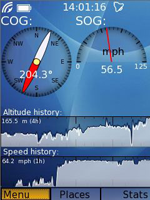
Basic info
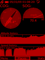
Basic information screen displays course (COG) and speed (SOG) (choice of method of calculating the speed, can eliminate GPS problems at low speeds) and a graph of the history of altitude and speed with a variable scale. The area of the speed graph allows the distance travelled to be estimated.
Position & track
Current position appears against most points in nearby surroundings. The database of points is global, of a high quality and by using its own compression and index format it is quick and small (whole world – 350MB, you do not have to download or prepare any data before you go, as they are with you at all times). As an optional feature it can show you the route of movement.
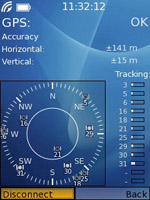
GPS status
General information about visible satellites, their signal quality and the current horizontal and vertical accuracy. You can activate and deactivate the GPS and see whether status is- OK FIX, NO FIX, NO DATA.
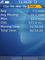
Statistics
Summary statistics are added together, e.g. for a whole excursion or for all types of movement, regardless of which user memory is active. Find at any time, as in all stats, trip and user - the distance, moving time, total time, average speed of movement and overall time.
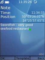
Notes
You can enter any number of longer notes; the system will connect them with the current location and time. You can later rewrite or amend the notes, which means you can insert a blank note and complete it when you rest in the tent or hotel. Alternatively, to make it faster, you can use your own templates and you can also insert the names of landmarks chosen from the smart bearing view.
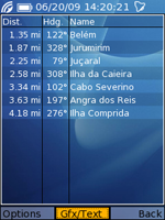
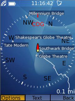
Smart bearing
In text mode nearest landmarks are displayed, and their distance and bearing from your position. Ideal for determining your position to give to the local, for rescuers, etc., or for meeting with other members of the expedition. It is always easier to go to a place that is 1 km south of the church than by using coordinates ....
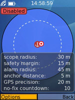
Anchor alarm & alerts
Developed for safe anchorage, movement of the ship outside the range of the chain length is indicated acoustically with maximum volume. The algorithm works for motion detection and stoppages also, which are important for later work with the data (one remembers that the second stop of the day was the most important).
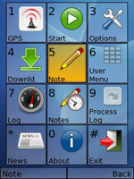
System menu
Optimized function keys that can be easily remembered, which gives the ability to control the application from memory. Uses the number keys as well as the green and red talk button, function keys and cursor keys. Each function is accessible by 2, or max. 3 keystrokes!
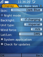
Skins
Choose from a choice of skins, with a combination of colours that best suit your eyes, taste, display or lighting conditions. Intelligent backlight - disabled, permanently or permanently when charging (ideal for holders in cars, boats, etc.). The choice of either nautical or land units of measurement.
Night mode
The combination of muted red and black color protects your eyes from glare when looking at the screen at night or in poor visibility. Tuned for maximum contrast and for reading the data with ease. Ideal for permanent backlight for night navigation or car journey and also for brief glances at the display during night walking.
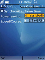
Battery life
Configurable power saving mode which switches off the GPS if the signal is lost. As you enter a building, cave or a deep valley, the system turns off the GPS itself and then tries to regain a fix at regular intervals. Losses and recoveries of the signal are indicated by a sound! This extends the battery life up to two times. The settings is optimized for both, normal mode or assisted GPS.